
Our Winter Vacation '04 - Page 4
| Previous | Next | Page 1,2,3,5,6 |
 |
 |
 |
 |
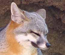 |
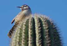
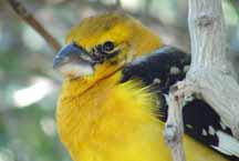
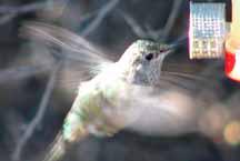
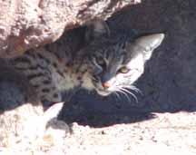
From our home base at Casa Grande, we next decided to head toward Nogales, Mexico. Dave had never been in Mexico and he thought it would be nice to go there, just so he could say he had been there. It was another very cold morning when we left with frost on the ground in places. After reaching Tucson, we decided go to the Desert Museum, which is in the hills southwest of town. The Arizona-Sonora Desert Museum is a world-renowned zoo, natural history museum and botanical garden, all in one place! Exhibits re-create the natural landscape of the Sonoran Desert Region so realistically you cannot tell where the museum ends and the desert begins. Within the Museum grounds, there are more than 300 animal species and 1,200 kinds of plants. There are almost 2 miles of paths traversing 21 acres of beautiful desert where its possible to see mountain lions, prairie dogs, Gila monsters, javelins, wolves, fox, mountain sheep, all kinds of birds and plant life, and much more. The museum advertises that it has hosted millions of visitors in the last 50 years with its exhibits of live animals in "astonishingly natural settings", while amusing and instructing people with fascinating educational programs. The Museum has also gained worldwide repute in the scientific community as an institution committed to researching and protecting the land, plants, and the animals of the Sonoran Desert region. It was a truly worthwhile experience for us as it was very entertaining as well as educational with staff available through out the grounds to demonstrate and answer questions. Of special fun for us was the humming bird enclosure where we could get up close and personal with all kinds of hummingbirds. We also had never seen javelins, which are essentially large wild pigs, and we decided that they are actually quite ugly and not something we would want to pet.
From the Desert Museum we headed south to Nogales and arrived there in the early afternoon. We found a place to park on a residential street about two blocks west from the border entry station. On the south side of the street, next to the sidewalk was a 15-foot high metal fence, which marked the border. We could see TV cameras mounted high up next to the border that surveyed the area, and there were border patrol cars manned nearby that were keeping a watch on things. It seemed a little intimidating, but we locked the car and proceeded to the border entrance on foot. There was no problem in crossing the border as we casually strolled across without stopping; there was no one there to ask us questions, or to inquire as to where we were going, or to look at passports. However, we did get an immediate greeting from all the locals who wanted our attention, and we definitely felt some tension from all the attention we were getting. People were continually directing us this way and that trying to get us to survey their wares and to sell us things. The sidewalks were crammed with so many people and goods that it was difficult to move forward and difficult to contemplate anything except how to get away from it all. We held each other's hand tightly and we quickly (as fast as we could) circumnavigated the block and returned to the border station where US Customs personally welcomed us back. It was a relief to be back, and Dave could now say that he had been to Mexico.
 |
 |
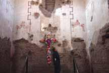 |
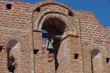
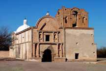
Heading back north, we decided to stop at the Tumacacori National Historic Park, about 19 miles north of Nogales. Here, in the upper Santa Cruz River Valley of southern Arizona, is located the abandoned ruins of the Spanish colonial mission of San Jose de Tumacaori. This is also the headquarters for another outlying mission, Los Santos Angeles de Guevavi (about 15 miles north). Mission San Jose was initially established as Mission San Cayetano de Tumacacori in 1691 (the oldest missions site in Arizona) by the missionary priest Father Kino (mentioned on Page 3, and described below), and then it was moved to the west side of the Santa Cruz River in 1751 and renamed Jan Jose de Tumacacori, which we see today. The remains of the building now standing is an edition from the early 1800's, which was then abandoned in 1848 after a hard winter. The history to be appreciated here originates in 1492 when Christopher Columbus discovered the new world and claimed it for the glory of Spain. Within 50 years, Spain's domain had spread to include South America, Central America, Mexico, and North America (clear up to Alaska). A wave of conquistadors overpowered the native peoples and their lands, including the Pima Indians in this area of Arizona. The Spanish then initiated the mission system to make citizens out of the people in the land they conquered, and to help control the new colonies. Jesuit priests were sent to do this, however, their main "mission" was to convert soles to Christianity, which they did. The natives were enticed by food, clothing, and supplies that became available to them. One of the most famous priests in this area was Father Eusebio Francisco Kino, who was tireless in his travels, establishing over 20 missions and visitas in what is today northern Mexico and southern Arizona. He was born in Italy in 1645, entered Jesuit College in Innsbruck, Austria, and attended the universities of Landsberg, Inlolstadt, Innsbruck, Munich, and Oehingen. He was an astronomer and cartographer, and mapped the Sea of Cortez and Baja California; being the first one to prove that Baja was a peninsula and not an island. He introduced native peoples to new crops such as wheat, and also introduced them to domesticated animals such as cattle and sheep, making them self-sufficient. He was noted for establishing good relations with the native peoples, by treating them with respect and by learning their language. He brought peace and security to the Pima indians and helped to bring them together in resisting the fierce Apache tribes, thereby getting their devotion as their leader and advocate. This was truly a great man! Although, the ruins here are in poor condition, it was possible to visualize what had once been a very beautiful place.
From the historic park, we headed up north to Green Valley and then east into Madera Canyon. We found ourselves in a different environment in this place for we were in higher country where there were trees and shade amongst the high mountainous hills. Actually, it was getting into late afternoon and we had driven way past our intended destination, which was the home of one of Dave's buddies from high school. After making a phone call and back tracking quite a ways back down from the hills, we found the nice new home of his friend in a brand new community in the middle of the desert. We stayed only about half an hour, but we were shown that a desert community can be a pretty nice place to live, at least in the winter season. Dave's friend and his wife were artists and they were in the process of finishing up some remodeling for an art studio.
 |
 |
 |
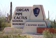
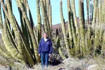
Our next excursion took us southwest from our base at Casa Grand to the Organ Pipe Cactus National Monument. This is actually a park that covers a lot of territory south of Gila Bend next to the Mexican border. From the park entrance, we traveled about 15 miles to the park headquarters and visitor center where we stopped to look at exhibits and listen to a ranger naturalist giving a talk about the area. This area was set aside to protect the Organ Pipe cactus which is common in Mexico, but which only extends north into this area of Arizona. In 1976, the United Nations designated the monument as an International Biosphere Reserve that houses one of the earth's major ecosystems. We learned about the two long back country roads that can be taken that loops you through the heart of the scenic area, and we also learned that you need to be very careful to avoid the approximately 100,000 Mexicans (some of who are desperate drug smugglers) who use this park each year to enter the US. The park shares a 30-mile border with Mexico, and about half of the border is closely followed by Mexican highway route 2. This has provided Mexicans with easy access as they annually create about 50 additional miles of clandestine roads in the park. We were also warned to carry lots of water in this hot country. Lucky for us, it was not hot, just very comfortable, and we saw no Mexicans (but maybe they saw us).
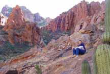 |
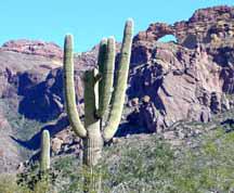
On the smaller 21 mile eastern loop road (the Ajo Mountain Drive), we stopped, got on our hiking shoes and headed up into Arch Canyon and the natural arch visible in the distance. It was interesting to be up close to the vegetation and the various species of cacti, and to see the interesting rocks (some of which Dave thought contained manganese nodules). We ended our hike about a mile and a half from the car, high up behind the arch at the top of the mountain, and then decided to come back down because it was late in the afternoon. We saw some beautiful country in this place and wished we had more time to hike and explore. After arriving back at the car, we finished the scenic loop and then continued to head south about 5 miles to where we reached the Mexican border at Lukeville. This is a small place that has an RV park, restaurant, grocery store, post office, laundromat, gas station, and the border crossing. We stopped here for dinner and then headed back to Casa Grande. On the way back to Casa Grande, we were stopped once at a border patrol checkpoint, and we later passed by another where we did not have to stop. It is quite evident that the Border Control people are working night and day, even quite far from the border to find the "illegals".
| Previous | Top | Next |